Looking for a cheaper GIS conference that still offers loads of great content and networking opportunties? State of the Map US is coming up and you cannot beat these prices.
We even have playlists of talks from previous years so you can see if it may be right for you. Take a look and I hope to see some of you in Boston!
https://www.youtube.com/watch?v=zkEJrLrnArE&list=PLqjPa29lMiE3msEjJS-QE5MTq1Ew0djYd


 Don Meltz


![[1] Drone images in a transect. The images must have GPS metadata - position and also orientation](https://cdn.masto.host/mapstodonspace/media_attachments/files/114/186/213/932/061/516/original/f352d8bf90b02501.png "[1] Drone images in a transect. The images must have GPS metadata - position and also orientation")
![[2] Image footprints from DroneDB CLI as black outlines. You will need to adjust the styling for this effect](https://cdn.masto.host/mapstodonspace/media_attachments/files/114/186/213/950/846/831/original/916300627ff1a988.png "[2] Image footprints from DroneDB CLI as black outlines. You will need to adjust the styling for this effect")
![[3] Dissolved image footprint polygons as a single purple polygon](https://cdn.masto.host/mapstodonspace/media_attachments/files/114/186/213/653/827/170/original/7a79af9053cf601b.png "[3] Dissolved image footprint polygons as a single purple polygon")
![[4] Dissolved footprints, reprojected to a CRS expressed in metres and labelled with the $area. The label field reads:
to_string(round($area,2)) || ' square metres'
...which rounds the $area attribute to 2 decimal places, converts it to a string, then concatenates it with the context string contaning units.](https://cdn.masto.host/mapstodonspace/media_attachments/files/114/186/213/705/299/604/original/2919095816a95f77.png "[4] Dissolved footprints, reprojected to a CRS expressed in metres and labelled with the $area. The label field reads:
to_string(round($area,2)) || ' square metres'
...which rounds the $area attribute to 2 decimal places, converts it to a string, then concatenates it with the context string contaning units.")


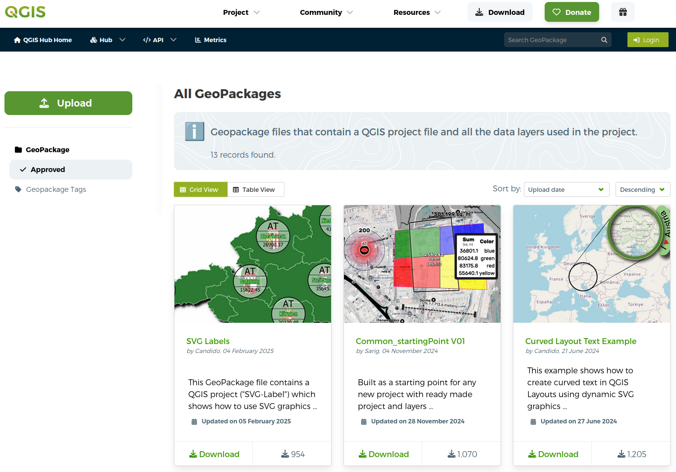
 project (incl. all your layers and data) in a single